

Washington, D.C. Drone Rules: 5 Steps to Fly Legally and Get FRZ Permits
Routine drone flights are effectively off-limits across most of Washington, D.C. The inner 15-mile ring around Reagan National Airport is closed to unauthorized drone activity, full stop. The outer ring, between 15 and 30 miles out, permits limited flights under standard FAA rules: registration, altitude under 400 feet, and visual line-of-sight. Anything inside the inner ring requires a waiver through the FAA and the Transportation Security Administration (TSA) before you launch.
Understanding DC Drone Laws: What the SFRA and FRZ Actually Mean
Washington, D.C. sits inside a Special Flight Rules Area (SFRA), a 30-mile circle drawn around Ronald Reagan Washington National Airport (DCA). Inside that circle, standard drone rules that apply everywhere else in the country simply don’t hold. The FAA divides this airspace into two rings, and which one you’re standing in determines whether you’re breaking federal law by pressing your remote’s power button.
The outer ring stretches from 15 to 30 miles out from DCA. Flights here are legal, provided you follow a specific set of operating conditions covered in the next section.
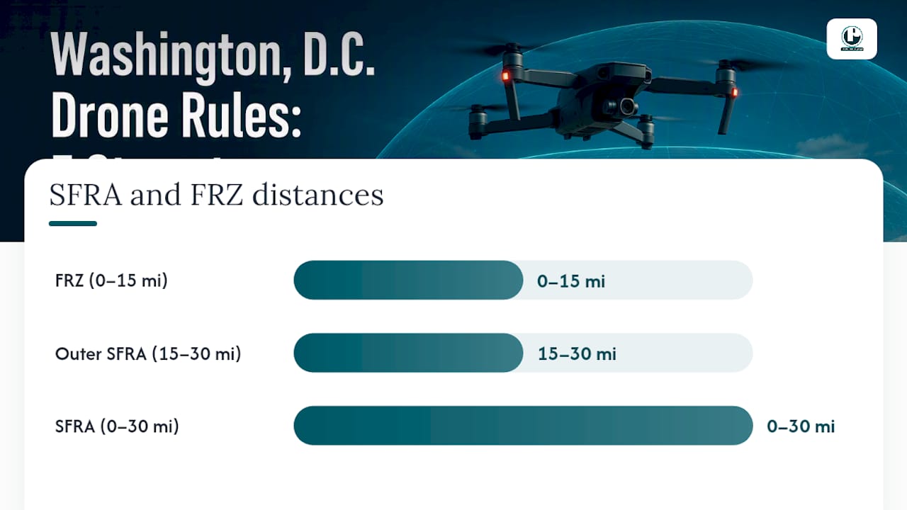
The inner ring, called the Flight Restricted Zone (FRZ), reaches 15 miles out. This is where things get serious. The FRZ covers downtown Washington, the National Mall, the Capitol, the White House, the Pentagon, and most of what a visitor would call “DC.” Flying here without FAA and TSA authorization is prohibited, and it doesn’t matter if your drone weighs half a pound and you just wanted a shot of the Washington Monument at sunset.
Two legal instruments give this restriction teeth:
14 CFR Part 93, Subpart V establishes the SFRA in the eCFR and defines its boundaries in regulatory language.
FDC NOTAMs (Notices to Air Missions) supplement Part 93 with the operating instructions currently in force, including special security procedures.
The FRZ isn’t a suggestion or a courtesy zone. It’s the most locked down piece of airspace in the country outside active military exercises, and the Dc labels the surrounding area a “No Drone Zone” for a reason.
The Rules for Flying a Drone in the Outer Ring (15 to 30 Miles)
If your launch point falls between 15 and 30 miles from DCA, you’re in legal territory, but only if you meet a specific checklist. Hobbyists fly here under the Exception for Limited Recreational Operations, a provision found at 49 USC 44809. Commercial operators, including anyone shooting content for a business or client, fall under Part 107 instead.
Here’s what both groups need to nail down before takeoff:
Register the aircraft. Any drone weighing more than 0.55 pounds gets registered with the FAA, and you carry proof of registration during flight.
Stay under 55 pounds. That’s the total weight limit including everything attached, cameras and payloads included.
Fly below 400 feet above ground level. This ceiling applies throughout the outer ring, no exceptions for “just a quick higher shot.”
Maintain visual line-of-sight. You or a visual observer must be able to see the aircraft with your own eyes at all times, not through binoculars or a screen.
Fly in daylight and clear weather (VMC). No night flights, no flying into clouds or fog.
Never interfere with manned aircraft. DCA and nearby airports mean real air traffic is a constant factor, not a hypothetical.
The credential you need depends on your category. Recreational fliers pass the TRUST exam, a free online test the FAA requires before any hobby flight. Part 107 operators need an actual Remote Pilot Certificate, which involves an aeronautical knowledge test at an approved testing center.
Pro Tip: Even a perfectly legal outer-ring flight can drift into trouble if your drone loses GPS lock and wanders toward the inner ring. Build in a buffer of at least a mile from the 15-mile line before you ever launch.
Getting FRZ Authorization: The FAA and TSA Waiver Process
Flying inside the FRZ isn’t impossible. It’s just genuinely hard to get approved, by design. Authorization runs through what the TSA calls the Waiver and Airspace Access Program (AAP), and it has two separate halves that both have to clear before you get a green light.
The first half is an FAA safety review, handled through the same system as a standard waiver or Certificate of Authorization (COA), submitted at waivers.faa.gov. The FAA is checking whether your proposed flight is operationally safe: altitude, area, equipment, pilot qualifications.
The second half is a TSA security review. This is the piece most first-time applicants underestimate, and it’s where the TSA’s published guidelines get specific about paperwork:
A client or sponsor letter, on official letterhead, stating the purpose of the flight
Detailed maps showing the operating area in decimal degrees, both large-scale and overview versions
Coordination information for the local law enforcement organization (LEO) that will monitor the flight
A written statement of work describing exactly what the drone will do
Named roles for the remote pilot in command (RPIC) and any visual observers
Operations within 7 nautical miles of the DCA VOR/DME face additional scrutiny, including restrictions on live broadcasting during many waivered flights. Waivers can also be time-limited and actively monitored during the flight window, not just reviewed on paper beforehand.
Vague or overly broad requests get rejected more than any other kind. Precision isn’t optional here. It’s the difference between an approved application and weeks of resubmission.
Enforcement, NOTAMs, and Checking Live Airspace Status
Noncompliance in DC airspace isn’t a paperwork problem. It’s a security problem, and it gets treated that way. The FDC NOTAM governing the SFRA spells out that unauthorized aircraft may face interception, detention, and administrative penalties. Multiple federal agencies coordinate on enforcement, which means a rogue drone over the Mall can trigger a security response well beyond a simple FAA fine.
Real consequences include:
Physical interception by law enforcement or security personnel
Seizure or destruction of the aircraft if it’s deemed a threat
Civil penalties from the FAA, sometimes running into thousands of dollars
Potential criminal charges, which DC’s own airspace advisory explicitly warns about
NOTAMs change. A flight that was fine last month can be grounded today because of a security event, a VIP visit, or a temporary flight restriction (TFR) nobody announced on the news. Check the FAA’s live NOTAM search immediately before any planned flight, not the night before. If you’re unsure which ring you’re in or whether a TFR is active, the National Capital Region Coordination Center (NCRCC) can help clarify current restrictions before you make a mistake that’s hard to undo.
A Pre-Flight Checklist for Legal Drone Operations Near DC
Running through five steps before you ever pick up the controller solves most of the problems that get drone operators in trouble around the capital.
Confirm your exact coordinates and ring. Use FAA mapping resources to determine whether your launch and flight path stay entirely outside the 15-mile FRZ.
Check current NOTAMs and TFRs. Do this the same day, ideally within an hour of your planned flight. Call the NCRCC if anything looks ambiguous.
Verify credentials and aircraft specs. Confirm your registration is current, you hold the right credential (TRUST or Remote Pilot Certificate), and your aircraft stays under 55 pounds.
Assemble authorization paperwork if needed. For any FRZ operation, that means a sponsor letter, decimal-degree maps, and LEO contact information submitted through waivers.faa.gov and the TSA AAP process well ahead of your date.
Coordinate on the day of the flight. If law enforcement coordination is part of your waiver, confirm the contact is expecting you, rehearse your visual line-of-sight setup, and keep your operating area as tight as your approval allows.
Pro Tip: Print your waiver approval and carry it during the flight. Verbal confirmation of authorization means nothing to an officer standing next to your launch point.
Drone Rules for Special Events and Government Gatherings in DC
Presidential inaugurations, State of the Union addresses, major protests, and large public gatherings routinely trigger temporary flight restrictions that stack on top of the permanent SFRA and FRZ rules. Such TFRs can expand the no-fly zone well beyond the standard 15-mile FRZ boundary for the duration of the event, and they often appear on short notice.
If you’re planning to film or fly anywhere near a scheduled government event, a national memorial ceremony, or a large public demonstration, treat the standing SFRA rules as your floor, not your ceiling. A TFR issued for a specific event can override a previously approved waiver entirely, grounding operations that were legal the week before. This is precisely why checking NOTAMs the day of your flight matters more in DC than almost anywhere else in the country: an approval you received a month ago doesn’t protect you from a restriction issued yesterday.
Security presence during these events is also considerably heavier. Secret Service, U.S. Capitol Police, and other federal agencies actively monitor for unauthorized aircraft during high-profile gatherings, and response times for interception are faster than during ordinary days. If your work involves covering events like these, the smart move is contacting the NCRCC directly during the planning phase rather than assuming your existing paperwork still applies.
Drone Privacy Laws and How They Apply in Washington, D.C.
Airspace authorization and privacy law are two separate legal questions, and clearing one doesn’t clear the other. Getting an FAA and TSA waiver to fly inside the FRZ says nothing about whether you’re allowed to record identifiable people on private property without consent.
The District follows general principles that most U.S. jurisdictions apply to aerial recording: operators can generally photograph what’s visible from public airspace, but capturing footage that intrudes on a reasonable expectation of privacy (through a window, over a fence into a private yard, focused tightly on identifiable individuals) can expose an operator to civil liability separate from any FAA violation. Federal buildings and monuments add another wrinkle. Filming government facilities is often legal from public space, but security personnel may still stop or question operators near sensitive sites regardless of whether the flight itself was authorized.
For anyone shooting commercial content in the district, this means airspace compliance is step one, not the whole picture. A production team also needs a plan for consent, for avoiding unnecessary footage of private residences along a flight path, and for handling security personnel who may not distinguish between “authorized” and “harmless” on sight.
Drone Registration Requirements Specific to Washington, D.C.
Registration in DC follows the same federal system used nationwide, but the stakes are higher because enforcement in this airspace is active rather than theoretical. Any drone weighing more than 0.55 pounds at takeoff gets registered with the FAA, and that registration number gets marked on the aircraft itself.
There’s no separate DC-specific registry layered on top of the federal one. What changes is what registration actually buys you. Outside the SFRA, an unregistered drone flying casually might go unnoticed. Inside the 30-mile SFRA, and especially near the FRZ, registration paperwork is one of the first things security personnel or law enforcement will ask about if your aircraft draws attention. Carrying proof of registration, along with your TRUST completion certificate or Remote Pilot Certificate, isn’t just a formality here. It’s the fastest way to demonstrate you’re a legitimate operator rather than a threat worth escalating.
Commercial operators registering under Part 107 follow the same process but through the FAA’s DroneZone portal with their certificate number attached. Either way, registration has to happen before the first flight, not after.
Recreational vs. Commercial Drone Use in Washington, D.C.
The line between “hobbyist” and “commercial operator” determines which set of federal rules governs your flight, and DC’s restrictive airspace makes that distinction matter more here than in most of the country.
Recreational flying falls under the Exception for Limited Recreational Operations. It’s meant for genuine hobby use: no compensation, no business purpose, flown strictly for personal enjoyment. Pilots pass the TRUST exam once and keep the certificate on hand.
Commercial use, meaning any flight tied to compensation or a business purpose, including real estate photography, event coverage, or promotional video work, falls under Part 107. This requires passing the FAA’s aeronautical knowledge test and holding an actual Remote Pilot Certificate, a meaningfully higher bar than TRUST.
The distinction affects waiver applications too. A commercial operator seeking FRZ authorization for a client project will typically need to include a statement of work and sponsor letter describing the commercial purpose, documentation a purely recreational applicant wouldn’t provide in the same form. If you’re flying for anyone other than yourself, for any form of payment or business benefit, assume you fall under Part 107 rules and prepare your waiver application accordingly.
Where to Report Drone Incidents or Suspicious Activity in DC
Spotting a drone over the Capitol grounds or the National Mall that clearly isn’t part of an authorized operation is worth reporting, and DC has established channels for exactly that. The NCRCC serves as a central coordination point for airspace concerns in the National Capital Region and can direct reports to the appropriate response agency.
For active security concerns, particularly anything happening near federal buildings, monuments, or during a government event, contacting local law enforcement or U.S. Capitol Police directly is the faster route. For general FAA regulatory violations, such as a drone clearly flying above 400 feet or well outside a hobbyist’s visual line-of-sight in the outer ring, the FAA maintains its own complaint process through regional Flight Standards District Offices.
The practical rule: if something feels like an immediate security concern, call it in to law enforcement right away rather than waiting to sort out which specific agency has jurisdiction. Coordination between the FAA, TSA, NCRCC, and local police in this airspace is built for exactly that kind of fast handoff.
When to Bring In a Professional for Permitted Aerial Filming in DC
Everything covered above gets considerably more complicated once a real production is on the line. A waiver application for a corporate video shoot near the Capitol, a documentary sequence over the Mall, or event coverage inside 7 nautical miles of DCA involves more moving pieces than most in-house teams have bandwidth for: sponsor letters, decimal-degree mapping, LEO coordination, and a statement of work that has to be specific enough to survive TSA review on the first pass.
A well-established video production company has extensive experience producing video content across the DC metro area, working with government agencies, nonprofits, and corporate clients who need footage that requires this exact kind of permit navigation. When a shoot falls inside the FRZ, involves a live event with a compressed timeline, or needs coordination with law enforcement on the ground, having a production partner who has already been through the FAA and TSA waiver process removes a lot of the guesswork that trips up first-time applicants.
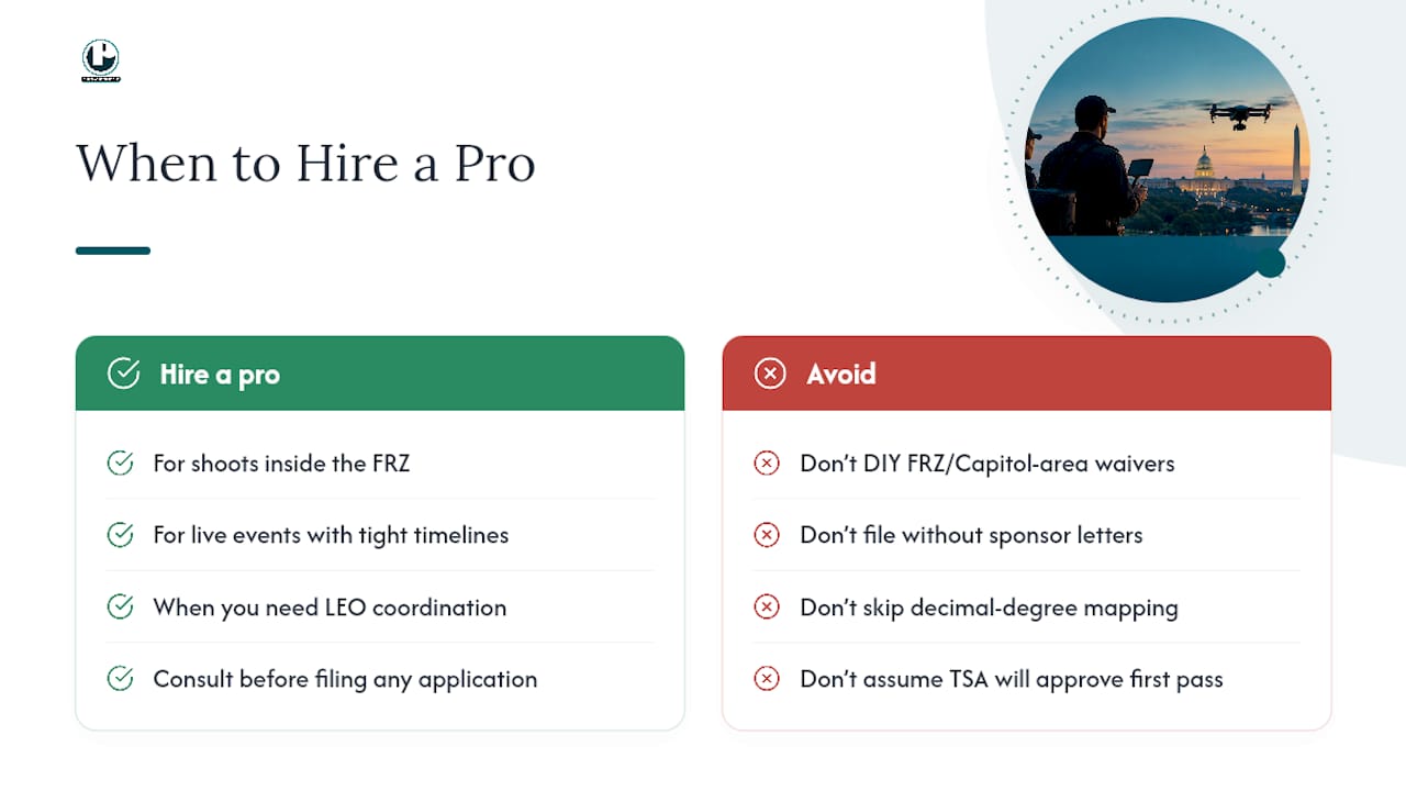
If your project involves aerial footage anywhere in the district, particularly near federal buildings, the Mall, or during a scheduled public event, the smartest first move is a conversation before you file anything. Reach out through Puritano’s video production page to talk through what your shoot actually needs, and whether a waiver, a sponsor letter, or a fully permitted flight plan gets you there without losing your shoot date to a rejected application.
Sources
FAQ
Is Washington, D.C. Restricted Airspace?
Yes. The district sits inside a 30-mile Special Flight Rules Area centered on Reagan National Airport, with a 15-mile inner ring, the Flight Restricted Zone, where drone flights are prohibited without FAA and TSA authorization.
Is DC Still a No-Fly Zone?
The inner 15-mile FRZ remains closed to unauthorized drone flights, and DC’s own airspace guidance still labels the region a No Drone Zone. The outer ring, from 15 to 30 miles out, allows flights that follow standard FAA operating conditions.
Can I Fly a Drone Over the White House?
No. The White House sits well within the 15-mile FRZ, one of the most heavily restricted pieces of airspace in the country, and flying there without specific federal authorization risks interception and serious penalties under the FDC NOTAM governing the SFRA.
Is It Legal for My Neighbor to Fly a Drone Over My House?
It depends on where your house sits relative to the SFRA rings and whether the flight follows FAA rules like altitude limits and visual line-of-sight. Airspace legality and privacy law are separate questions, and a technically legal flight can still raise privacy concerns if it records identifiable activity on private property without consent.
How Do I Get Authorization to Fly Inside the DC FRZ?
Authorization requires clearing a two-part review: an FAA safety and airspace check plus a TSA security review, both submitted through the Waiver and Airspace Access Program described in TSA’s application guidelines. Applicants need a sponsor letter, precise decimal-degree maps, and law enforcement coordination details before submitting.
Recommended
Comments